

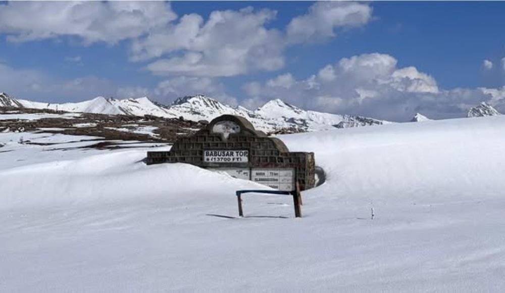
Babusar Pass, also known as Babusar Top, is one of Pakistan’s most beautiful mountain passes. It is 4,173 meters (13,691 feet) above sea level and is a must-see for adventure seekers, nature lovers, and road-trippers alike. This dramatic high-altitude crossing connects the lush green valleys of Khyber Pakhtunkhwa with the rugged beauty of Gilgit-Baltistan. It is an important regional link and an unforgettable travel experience.
What is Babusar Top (Babusar Pass)?
The beautiful Kaghan Valley is 150 kilometers long, and Babusar Pass is at the northern end of it. It is the highest point in the valley that can be driven to, and it connects two different geographical and cultural areas of Pakistan. The pass connects Chilas on the famous Karakoram Highway (KKH) to the Kaghan Valley through Thak Nala. This is a different way to see Pakistan’s beautiful mountain scenery.
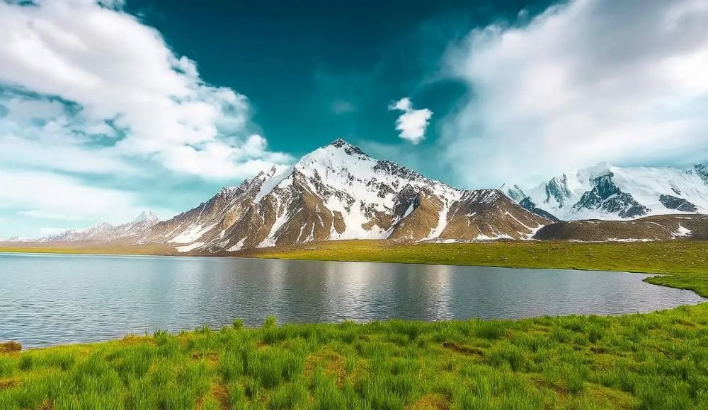
The trip to Babusar Top takes you through ecosystems that change from dense pine forests and alpine meadows to high-altitude land that is too dry for most plants to live. Visitors at the top are rewarded with stunning views of snow-capped peaks, including the powerful Nanga Parbat to the northeast and the towering Malika Parbat, which is over 17,000 feet high.
Why Babusar Pass is Famous Among Travelers
For a number of good reasons, Babusar Top has become famous among travelers from Pakistan and around the world:
Dramatic Scenery: The pass has some of the most beautiful views in Pakistan that are perfect for taking pictures. If the weather is good, you’ll see clouds floating below you, snow-covered peaks all around the horizon, and the stark beauty of high-altitude terrain that seems almost otherworldly. The Babusar Top location has views in every direction, which makes every hard kilometer worth it.
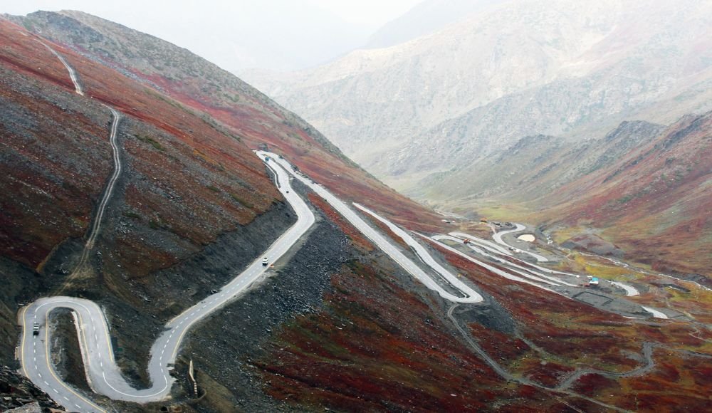
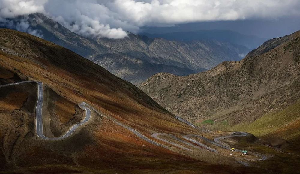
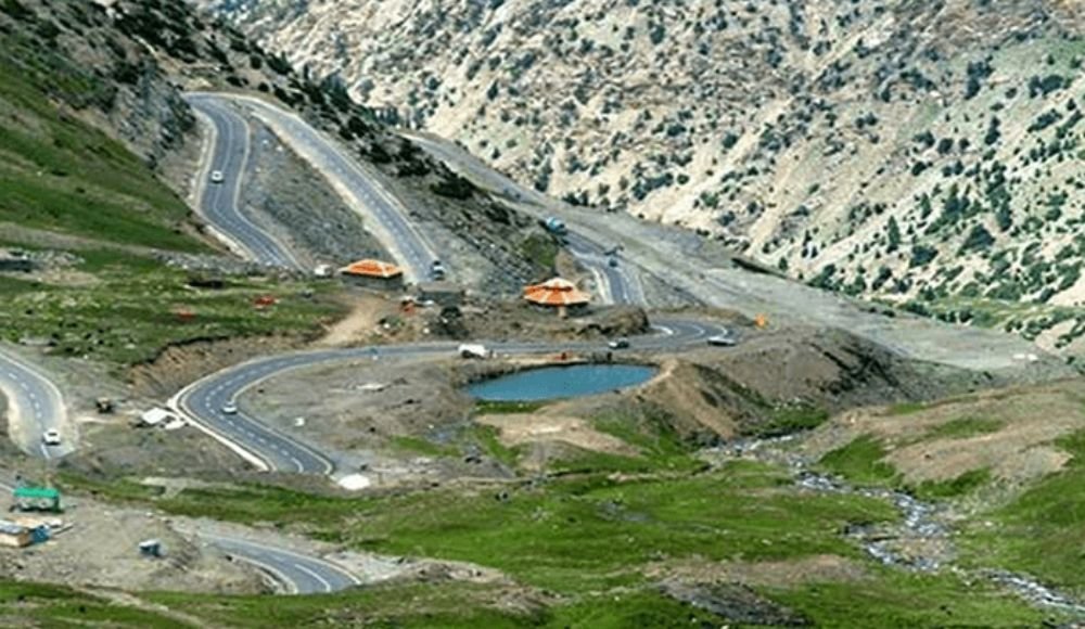
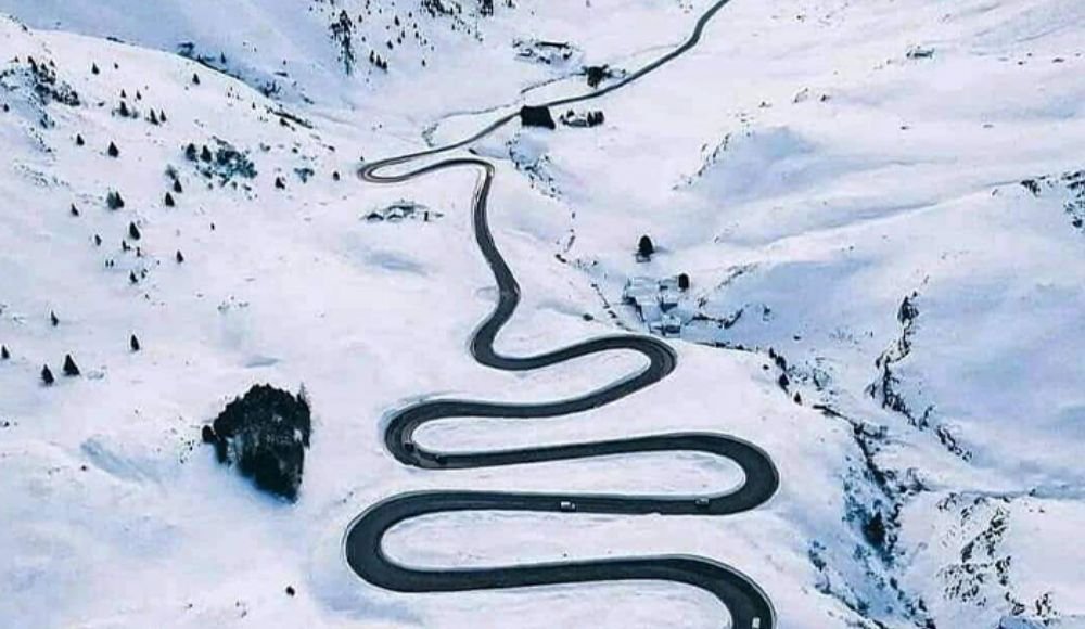
Engineering Marvel: The Babusar Top road is a testament to human determination and engineering skill. This road is carved into the sides of mountains and has hairpin turns and steep slopes. It is hard for drivers, but it gives them new views around every turn. The parts that have been fixed up recently have made the trip safer while keeping its adventurous spirit.
Strategic Connectivity: Babusar Pass is an important backup route that connects Khyber Pakhtunkhwa with Gilgit-Baltistan when the main routes are closed. Because of its strategic importance, road infrastructure has been constantly getting better, which helps both travelers and local communities.
Cultural Bridge: The pass is more than just a way to get from one place to another; it’s also a bridge between cultures and histories. This route has been used by traders, nomads, and travelers for hundreds of years, and people still use it today. Along the way, visitors experience the warm hospitality of mountain communities.
Adventure Appeal: For people who love road trips, motorcycles, and adventure travel, reaching the top of Babusar is a big deal. Travelers will remember this trip for years because of the hard roads, unpredictable weather, and amazing rewards.
Where Is Babusar Pass Located?
Location of Babusar Pass in Pakistan
Babusar Pass is in a good spot in northern Pakistan, where it naturally separates two different areas. The pass is at the very top of the Kaghan Valley in Khyber Pakhtunkhwa province, right on the border with Gilgit-Baltistan. This Babusar Top spot is the highest point in the whole Kaghan Valley that people can get to.
The pass is in the western Himalayan mountain range, which is part of the complicated network of ranges that make up Pakistan’s northern landscape. The stunning Malika Parbat and other peaks nearby make a dramatic amphitheater of mountains that shows off the area’s geological beauty.
Babusar Pass on the Map (Kaghan Valley to Chilas Connection)
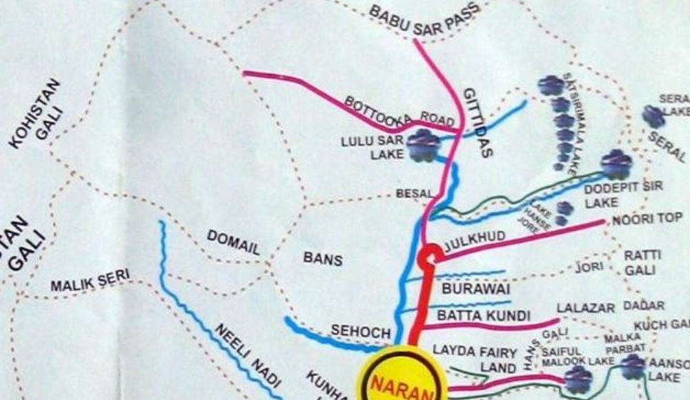
The N-15 national highway, also called the Naran-Chilas Road, has Babusar Pass as an important intersection on a map. The pass is basically the entrance to two major tourist areas:
Southern Approach: People from Islamabad and other big cities first get to the Kaghan Valley through Balakot and Mansehra. The path then goes through beautiful places like Naran, Batakundi, and Jhalkhand before going up to Babusar Top.
Northern Approach: The route starts at Chilas and goes up through the Thak Nala valley system before reaching Babusar Pass and then going down into the Kaghan Valley. It can be reached from Gilgit or the Karakoram Highway.
Babusar Top is an important link for travelers on Pakistan’s northern circuit because it offers a stunning alternative to longer routes through Skardu or Besham. The pass connects the Kaghan Valley, which is lush and full of trees, with the Gilgit-Baltistan region, which is dry and starkly beautiful. This gives travelers two very different landscapes in one trip.
Babusar Pass Height and Geographic Facts
Babusar Pass Height in Feet and Meters
The Babusar Top is an impressive 4,173 meters (13,691 feet) above sea level. To give you an idea of how high this is, Babusar Pass is higher than many ski resorts in Europe and is almost as high as the highest peaks in the Alps. Because of how high it is, this pass is definitely in the group of high-altitude mountain passes where the air is noticeably thinner and the weather can change quickly.
Because of its height, Babusar Top is also the highest point in the Kaghan Valley that can be reached by car. This makes it one of the highest drivable passes in Pakistan. There are only a few other passes in the country that are as high as or higher than this one, like Khunjerab Pass (4,714m) and Shandur Pass (3,738m).
Why Babusar Pass is One of the Highest Mountain Passes in Pakistan
Some of the highest land in the world can be found in northern Pakistan. There are many peaks that are over 8,000 meters high and many high-altitude passes. Babusar Pass is one of the most important of these for a number of reasons:
Accessibility: Babusar Top can be reached by regular cars (with caution) and motorcycles, unlike many very high passes that need special vehicles or trekking. This makes high-altitude experiences available to more people.
Year-Round Importance: The pass is only open during certain months, but it is still an important connection point during those months. This shows that altitude alone does not make a place less strategically valuable.
At 4,173 meters, Babusar Pass is higher than many famous alpine passes around the world. It gives you a real high-altitude experience with thin air, possible altitude effects, and the thrill of being among the clouds.
Climate and Terrain Overview
The land at Babusar Top shows how high and open it is. At the top, the landscape is mostly rocky and empty, with only hardy grasses and low-lying alpine shrubs growing there. Most of the year, snow covers the pass. Even in the summer, there are often snow banks along the road, which shows how extreme the weather is at Babusar Top.
The climate is alpine, which means it has:
• Summers are short and cool, with highs of around 11°C (52°F).
• Long, cold winters with a lot of snow and temperatures below zero
• Weather that changes quickly, bringing sunshine, rain, fog, and snow in a matter of hours
• Strong winds, especially at the top where it is open
• Thin atmosphere lets in a lot of UV radiation.
The mountains around the pass are even taller, and Malika Parbat, which is over 5,200 meters high, stands out in the sky. The temperature at Babusar Top changes a lot between day and night, so travelers should be ready for cold weather even in the summer.
History and Significance of Babusar Pass
Historical Importance of Babusar Pass
Historical records and local legends show that Babusar Pass has been an important mountain crossing for hundreds of years. Long before modern tourists found out how beautiful the pass was, it was an important trade, migration, and cultural exchange route because of where it was located.
Role in Trade and Regional Connectivity
Before the Karakoram Highway and other modern roads were built, mountain passes like Babusar Top were the main ways for people and goods to get around in northern Pakistan. Traders moved goods between the fertile valleys of Khyber Pakhtunkhwa and the mineral-rich areas of Gilgit-Baltistan. This created economic ties that helped bring the two regions together.
The pass also made it easier for people to move around during certain times of the year. Gujjar herders and other nomadic groups used to drive their animals through Babusar Pass in the summer to get to high-altitude grazing lands. This is still done today, but in a different way. These migrations kept pastoral livelihoods going and also kept cultural ties strong across mountain ranges.
Origin of the Name “Babusar”
The history behind the name “Babusar” is interesting. According to local legend, the pass was first called “Babur Top,” after Zahir-ud-din Muhammad Babur, the man who started the Mughal Empire. Historical records say that Babur traveled through this area in the early 16th century while he was trying to set up Mughal rule in the Indian subcontinent.
The pronunciation changed from “Babur” to “Babusar” over hundreds of years, but the link to the Mughal emperor is still part of local folklore. This etymology may or may not be correct, but it shows how important the pass was as a strategic mountain crossing for powerful empires and how it played a role in important historical events.
Routes to Babusar Pass
Route from Naran to Babusar Pass
Distance and Travel Time: The trip from Naran to Babusar Top is about 65 kilometers long and usually takes 1 hour and 45 minutes to 2 hours, depending on the weather, traffic, and road conditions. But most travelers stay much longer because the beautiful scenery makes them stop for pictures often.
Road Condition Details: The route from Naran to Babusar Pass has gotten a lot better in the last few years. The Babusar Top road is now paved for most of the trip, but the conditions change with the seasons. In the early summer (May–June), melting snow can make some parts of the road slippery. In the late summer (August–September), the road conditions are usually the best.
Key points along the route include:
- Batakundi: 16 kilometers from Naran, it has last-minute supplies and places to stay.
- Jhalkhand: The last stop before the pass, where people going to Babusar Top set up camp.
- Lulusar Lake: A beautiful turquoise lake about 45 kilometers from Naran that is often thought to be the best part of the trip.
The road goes from Naran’s height of about 2,500 meters to Babusar Top’s 4,173 meters, which is almost 1,700 meters higher. Along the way, there are many hairpin turns and steep hills that are hard for both cars and drivers.
Route from Chilas to Babusar Pass
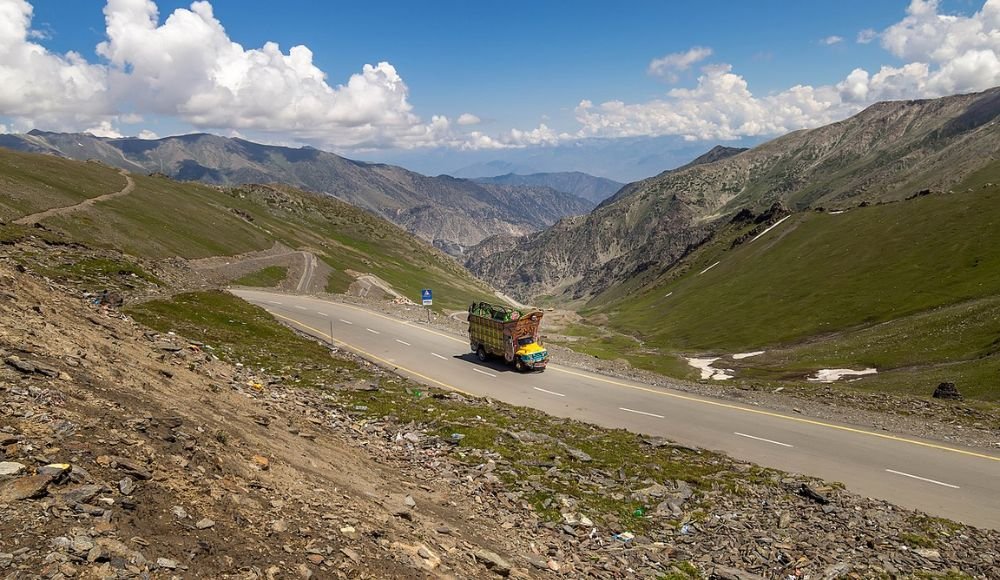
Distance and Difficulty Level: The Chilas to Babusar Pass route is about 110 kilometers long and takes 3 to 4 hours in good weather. Most people think this route is harder than the Naran approach because it has rougher road sections and steeper, more exposed switchbacks.
The climb from Chilas starts at a much lower elevation (about 1,250 meters), so the climb to Babusar Top is almost 3,000 meters of elevation gain. This is a big climb that can be hard on both cars and people who aren’t used to high altitudes.
Beautiful Views Along the Way: The Chilas approach takes you from the dry landscapes near the Karakoram Highway to lusher, forested areas, which is a big change. Some important points of view are:
- Indus River Panoramas: Early on in the trip, there are amazing views of the powerful Indus River as it cuts through mountain gorges.
- Thak Nala Valley: A beautiful side valley where you can see traditional mountain villages and seasonal settlements.
- Views from Babusar Summit: The first time you see Babusar Top coming out of the clouds from the north is very dramatic.
How the roads are in Babusar Pass
Current Road Condition and Surface Type
The Babusar Top road has seen a lot of improvements since 2025, especially on the Naran side. The National Highway Authority (NHA) has paved most of the road, but some parts are still being built or are at risk of seasonal damage from rockslides, snow, and heavy rains.
The road surface changes from well-paved tarmac on the main parts to rougher gravel on the parts that aren’t used as much. The Chilas route usually has rougher conditions than the Naran route, but work is being done to make the whole corridor more uniform.
Keep in mind that “road condition” can mean very different things at different times of the year. The Babusar Top road is usually at its best in the summer, from July to August. In the spring (May to June) and fall (September to October), however, it can be hard to drive because of snow melt, ice patches, and storms that come early or late in the season.
Are cars safe on Babusar Pass?
Yes, regular cars can get to Babusar Pass, but there are some important things to keep in mind. The road can handle regular cars, but the following conditions have a big impact on safety:
Things to think about when driving:
- Vehicles with high clearance work better, especially on rougher parts
- Sedans can make the trip, but you have to drive carefully.
- For the steep descents, it’s very important to have well-maintained brakes.
- The power of the engine is important; smaller engines may have trouble with the height and slopes
Things to Think About for Safety:
- It’s best to travel during the day (official hours are 7 AM to 6 PM).
- The weather must be clear; fog, rain, or snow make things much more dangerous.
- Drivers who have been on the mountain before are better at handling hairpin turns.
- There aren’t many emergency services at high altitudes.
Can Motorcycles and 4×4 Vehicles Access Babusar Top?
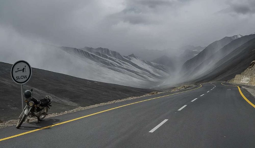
Motorcycles: Babusar Pass is a popular place for adventure motorcyclists to go, and bikes can easily get through. But riders should have:
• Have ridden in the mountains before
• Bikes that have enough power to climb hills
• The right gear to protect you from cold and changing weather
• Knowing that rescue services are limited if something goes wrong
Four-wheel-drive vehicles are best for Babusar Top because they give you better traction, control, and confidence on tough parts. If you’re going to be traveling early or late in the season when ice or snow might still be on the road, or if the weather is unpredictable, a 4×4 is a good choice.
The Best Time to Go to Babusar Pass
The best months to go to Babusar Pass
The best time to visit Babusar Pass is from the middle of June to the end of September. July and August are the best months because the roads are in the best shape and the weather is more stable.
June: Early season; the pass usually opens in the middle to late June after the snow has melted. The weather can be unpredictable because there are still snow banks, but adventurous travelers will be rewarded with fewer people and new mountain views.
July and August are the best months to visit Babusar Top because the weather is perfect. The weather is warmest (around 11°C), the roads are in the best shape, and all the facilities are open. But these months also see the most tourists, especially on weekends.
September: The air gets clearer and the visibility gets better as autumn begins, but the temperatures start to drop. By the end of September, there is a higher chance of early snow that could close the pass without warning. This month is good for people who want to be alone because there are fewer people around.
Weather by Season
June to August: Summer
- The temperature at Babusar Top is between 3 and 11 degrees Celsius (37 and 52 degrees Fahrenheit).
- Most days are clear, but there are clouds in the afternoon.
- Thunderstorms every now and then
- Cold nights that need warm layers
Fall (September to October):
- • The weather gets cooler, and it gets colder as winter gets closer.
- • Air that is clearer and crisper
- • More likely to have sudden changes in the weather
- • Snow could start falling as early as late September
Winter (November to May):
• Pass is completely closed because of a lot of snow
- Very cold, with temperatures well below freezing
- The snow is too deep for the road to be safe.
- No services or access for tourists
- When it snows, Babusar Pass is closed.
Babusar Pass closes at the same time every year:
Closure: Usually from late October to early November, when the snow starts to fall heavily. The date changes every year depending on the weather. The pass closed on October 29, 2024.
The National Highway Authority will be done clearing snow by the middle of May to the middle of June. The pass opened on May 21, 2025, but travelers were told to be careful because there was still snow on the sides of the roads.
Winter Conditions: During the months when the road is closed, snow can build up to several meters, making the Babusar Top road completely impassable. It is very dangerous and against the law to try to cross during this time.
The weather at Babusar Pass
The Weather at Babusar Top in the Summer
The weather at Babusar Top in the summer is cool and changes a lot. The 4,173-meter height keeps the summit cold even in the hottest months.
A Typical Summer Day:
- In the morning, the weather is often clear and crisp, which is great for traveling and taking pictures.
- Midday: Getting a little warmer, with highs of 10–12°C
- In the afternoon, clouds often form, and there is a chance of sudden fog or rain.
- Evening: The temperature could drop quickly, and strong winds could happen.
The weather at Babusar Top can change quickly. Before leaving, travelers should check the current temperature at Babusar Top and be ready for a range of weather conditions.
Snow and cold weather in the winter
In the winter, Babusar Pass becomes a snow fortress that no one can get through. The temperature at Babusar Top in the winter usually stays between -10°C and -25°C (14°F and -13°F), but the wind chill makes it feel even colder.
There is a lot of snow falling, and it keeps falling, piling up to bury the road under several meters of snow. These conditions last from November to May, so winter closure is absolutely necessary for safety.
Risks of Sudden Weather Changes and Fog
The weather at Babusar Top is probably the hardest to deal with because it is so unpredictable. Things can change quickly from clear skies to thick fog, rain, or snow. This instability is caused by:
- The pass is high up, which makes it open to fast-moving weather systems.
- Air from valleys that is full of moisture making clouds form quickly
- Drops in temperature cause fog and condensation to happen quickly
- Thunderstorms in the afternoon, especially during monsoon season
Fog is especially dangerous because it makes it hard to see more than a few meters on roads without guardrails and steep drop-offs. If fog rolls in while you’re driving, the safest thing to do is stop and wait for the weather to clear up instead of trying to drive through it.
Also Read: Top 10 Best Places to Visit in Hunza Valley
What to Do at Babusar Pass
Taking Pictures and Seeing Things
Babusar Top is a photographer’s dream come true, with endless chances to take pictures of Pakistan’s beautiful mountains:
- Summit Panoramas: The 360-degree views from the pass itself include Malika Parbat, Nanga Parbat (if the weather is good), and many smaller peaks.
- Snowscapes: Even in the summer, snow banks make for dramatic foreground elements.
- Cloud Play: The way clouds, mountains, and light interact makes compositions that change all the time.
- Traditional Life: Gujjar shepherds and their flocks add cultural elements to the land.
Enjoying Views of the Mountains from All Angles
Just standing at the top and taking in the huge view of the mountains is a powerful experience. The Babusar Top height puts you literally in the clouds, which gives you a sense of how big the Himalayas are.
Short Walks and Places to Look
Babusar Pass isn’t a place to go trekking, but short walks from the road give you better views:
- If you walk 100 to 200 meters away from the main road, you’ll find more places to see.
- The top area is easy to explore while still being able to see your car.
- Be careful because of the high altitude and rough ground.
Book Now: 12 Days Group Tour: Hunza & Skardu Valley
Animals and Natural Beauty
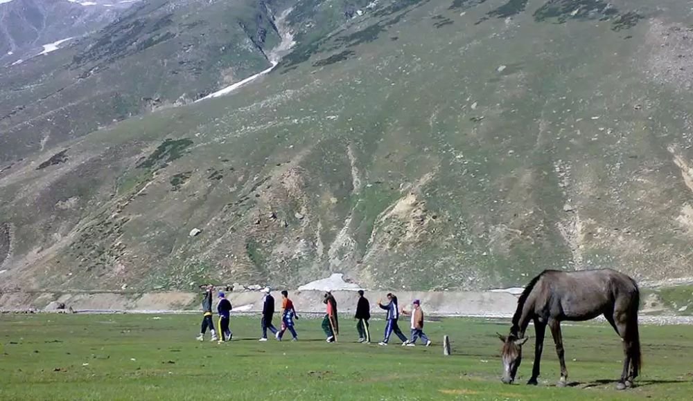
The Babusar Top area has a surprisingly wide range of wildlife that has adapted to harsh conditions:
- Himalayan marmots are often seen lying on rocks in the sun.
- Snowcocks and other birds that live at high altitudes
- Sometimes you can see mountain sheep and goats
- Alpine plants growing on rocky slopes
What to Bring to Babusar Pass
Things You Need to Wear
Layering is important when the weather at Babusar Top changes:
- Base layers, like thermal underwear
- Warm middle layers (wool or fleece)
- Outer shell that keeps out wind and water
- A warm hat and gloves (even in the summer)
- Strong, warm shoes
- Sunscreen and sunglasses (high UV at high altitudes)
Precautions for Food, Water, and Fuel
- Food: Bring snacks and meals; Babusar Top has few facilities (only basic dhabas)
- Water: Bring enough bottled water; staying hydrated can help you avoid altitude sickness.
- Fuel: Get fuel in Naran or Chilas; there are no fuel stations at the pass or nearby.
Items for emergencies and safety
- A basic first aid kit
- Medicines for altitude sickness (talk to your doctor before you go)
- A headlamp or flashlight
- A power bank and a mobile charger
- Numbers to call in case of an emergency
- Cash (there are no ATMs at high altitudes)
Also Read: Best Time to Visit Fairy Meadows for Breathtaking Views You’ll Never Forget
Travel Safety Tips for Babusar Pass
How to Avoid Altitude Sickness
At Babusar Top height (4,173m), the effects of altitude are possible:
- Go up slowly, spending some time in Naran before going higher
- Drink a lot of water
- Don’t drink alcohol or eat heavy meals.
- Know the signs: headache, nausea, and dizziness
- Go down if the symptoms get worse
Tips for Safe Driving
- • Travel during the day (official hours are 7 AM to 6 PM)
- • Go slowly on hairpin turns and steep parts of the road.
- • Check your brakes often; broken brakes cause a lot of accidents.
- • Be careful of cars coming from the other direction on narrow parts
- • Don’t stop in dangerous places to take pictures
- • Look at the weather before you leave
Availability of Mobile Networks and Signals
There isn’t much mobile coverage at Babusar Pass, and it isn’t very reliable:
- Some signals are available from major carriers in lower areas
- There is often no coverage at the summit
- Don’t count on your phone to work in an emergency.
- Tell other people about your travel plans before you leave.
Things to Do Near Babusar Pass
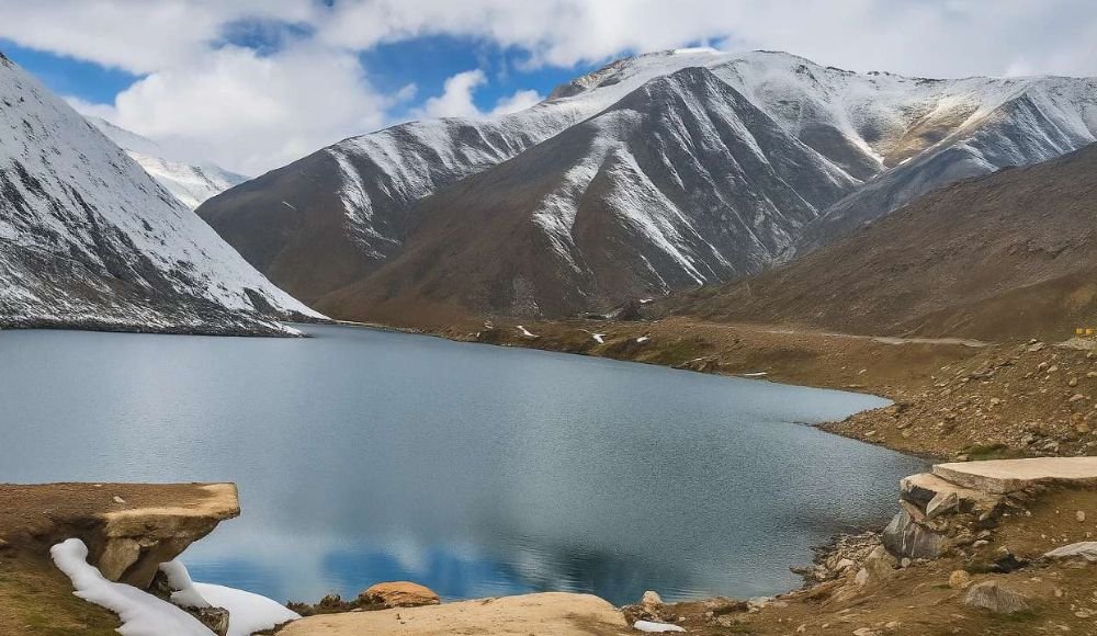
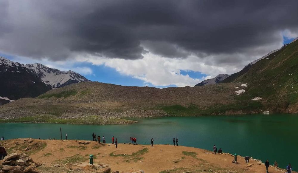
Lake Lulusar
Lulusar Lake is a beautiful alpine lake with turquoise waters that reflect the peaks around it. It is about 20 kilometers before Babusar Top when you are coming from Naran. It’s a great place to take pictures and rest before the last climb.
The Valley of Naran
Naran is the main tourist center, with hotels, restaurants, and shops. It is also the way to get to Babusar Pass. It’s the perfect place to stay for trips to Babusar Top because it has comfortable rooms and all the amenities you need.
Kaghan Valley
The larger Kaghan Valley has many attractions, such as Shogran, Lake Saif-ul-Muluk, Batakundi, and many hiking trails. This makes it easy to plan multi-day trips that include Babusar Pass.
Viewpoints for the Chilas and Indus Rivers
Chilas is on the north side and has great views of the Indus River as it cuts through huge gorges and access to the Karakoram Highway.
Families and people who are going to Babusar Pass for the first time
Is Babusar Pass a good place for families?
Families can stay at Babusar Pass, but there are some things to think about:
- Children: Must be able to deal with the effects of cold weather and high altitudes.
- Health: Everyone in the family should be in good health.
- Comfort: The trip will take hours and hours on winding roads in a car.
- Age: Very young kids or older people may have trouble with high altitudes.
Family trips to Babusar Top can make memories that will last a lifetime of Pakistan’s beautiful mountains if you plan ahead.
Travel Advice for Newbies
- If you’re going for the first time, you should:
- Book organized tours so you don’t have to worry about anything (for professional Babusar Pass packages, check out Eventica Travels, Pakistan’s award-winning tour operator).
- Check the weather before you leave
- Start early to get the most light possible
- Be ready for delays because of the weather
- If you’re not sure about driving in the mountains, hire experienced drivers.
Also Read: Best Time to Visit Naran Kaghan & Shogran: A Seasonal Guide
Questions and Answers about Babusar Pass
The highest point you can drive to in Kaghan Valley is Babusar Top, which is 4,173 meters (13,691 feet) above sea level.
No, Babusar Pass is only open from the middle of May or June to the end of October or the beginning of November. It closes in the winter because there is a lot of snow.
The trip from Naran takes about 1 hour and 45 minutes to 2 hours. Give yourself 3 to 4 hours from Chilas.
Babusar Pass is safe if you take the right precautions, travel during the day, and the weather is good. But the route has steep drops, hairpin turns, and high altitudes that you need to be careful around.
Both give you a different experience. Babusar Pass is higher up, has more dramatic scenery, and connects better to Hunza/Gilgit. Lowari Pass connects Chitral and is open all year round by tunnel. The “better” choice depends on where you’re going and how you’re getting there.
Babusar Pass is one of the most beautiful mountain experiences in Pakistan. It’s a trip that combines natural beauty, adventure, and the thrill of reaching one of the country’s highest points. The weather, road conditions, and location of Babusar Top make it harder to get there, which makes the experience more meaningful and the memories last longer.
Every traveler should go to Babusar Pass.
Babusar Top has something for everyone, whether you want to take dramatic photos, go on an adventure drive, learn about the culture, or just stand among Pakistan’s tallest peaks. The pass is more than just a way to get from one place to another; it’s a way to learn about Pakistan’s beautiful mountains and rich culture.
Taking care of the environment and being a responsible tourist
As more people come to Babusar Pass, it becomes more important to protect its delicate environment:
- Take all your trash with you; don’t leave any signs of your visit.
- Respect the traditional ways of life in the communities you visit.
- Hire local guides and use local services to help the local economy.
- Drive carefully to avoid accidents and harm to the environment
- Follow the rules, which say you can only travel during the day.
Let Eventica Travels Help You Plan Your Trip
Eventica Travels, Pakistan’s best tour company and award-winning travel agency, offers complete packages for travelers who want a stress-free, professionally planned Babusar Pass experience. These packages take care of all the details, making sure that everyone is safe, comfortable, and has a great time. Eventica makes your Babusar Top trip as amazing as the place itself by providing expert local knowledge, experienced drivers, and flexible itineraries.
Are you ready to see the magic of Babusar Pass? Get in touch with Eventica Travels today to plan your ideal trip to northern Pakistan, which will include Babusar Top, Hunza Valley, Naran, Kaghan, and more. Let Pakistan’s best tour company make your dreams of the mountains come true.
Travel Smart. Travel Safe. Travel with Eventica.


